![]()
![]()
Attitude Angle < 0.1°
Use-configurable Setting
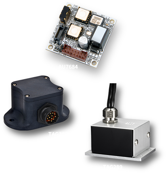
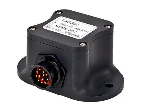
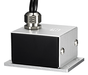
Waterproof Case (TAG320 / TAG310 / TAG300)
The MEMS IMU (Compact 3-Axis Inertial Sensor Unit) offers a cost-effective alternative to traditional inertial measurement systems. Available in both GNSS-compatible models and autonomous navigation versions using an Extended Kalman Filter, this series delivers outstanding functionality and versatility.
| Type / Part Number | TAG320N1000 | TAG320N2000 | TAG310N1000 |
|---|---|---|---|
 |
|
|
|
| Feature | Standard Model IP67 (Water and dust protect) |
High-Precision Model IP67 (Water and dust protect) |
Base Model IP67 (Water and dust protect) |
| Operation Mode Compare |
Leveling Calculation | ||
| Size | 83×47.9×20mm | ||
| Mass | 50g Max | ||
| Power Supply Voltage | 8 to 32V | 8 to 28V | |
| Communication Interface | CAN Standard + Extensions *Custom configurations can support CANFD |
CAN Standard + Extensions | |
| Output Data |
・Acceleration (X,Y,Z) ・Angular velocity (X,Y,Z) ・Attitude angle (Roll,Pitch,Yaw) |
||
| Angular Velocity | ±200°/s | ||
| Acceleration | ±4G | ±6G | ±4G |
| Angular Velocity Bias | 0.2°/s rms (Room temp.) | 0.1°/s rms (Room temp.) | 0.2°/s rms (Room temp.) |
| Acceleration Bias | 0.0392m/s² rms (Room temp.) | 0.0196m/s² rms (Room temp.) | 0.0392m/s² rms (Room temp.) |
| Operating Temp. Range | -40 to 85℃ | ||
| Bandwidth | 50Hz TYP. | 30Hz TYP. | |
| Output Cycle | 1,000Hz Max | ||
| Accessory | (Sold separately) Communication cable:EU8974N1 | ||
| Type / Part Number | TAG300N1x00 | TAG300N2x00 |
|---|---|---|
 |
|
|
| Feature | Compact, Low cost, High accuracy, Waterproof |
GNSS/INS/VS Waterproof |
| Operation Mode Compare |
Leveling Calculation | Leveling Calculation GNSS/INS/VS (User-configurable) |
| Size | 100×60×50mm | 100×60×50mm |
| Mass | 250g Max | 250g Max |
| Power Supply Voltage | 8~28V | 8~28V |
| Communication Interface | RS232/CAN | RS232/CAN |
| Output Data | ・Acceleration (X,Y,Z) ・Angular velocity (X,Y,Z) ・Attitude angle (Roll,Pitch,Yaw) ・GPS : Latitude, Longitude, GPS velocity (GPS module connection is required) |
・Acceleration (X,Y,Z) ・Angular velocity (X,Y,Z) ・Attitude angle (Roll,Pitch,Yaw) ・GPS : Latitude, Longitude, GPS velocity (GPS module connection is required) |
| Angular Velocity | ±200°/s | ±200°/s |
| Acceleration | ±3G / ±6G | ±3G / ±6G |
| Angular Velocity Bias | s0.2 °/ rms | 0.2 °/s rms |
| Acceleration Bias | 5mG | 5mG |
| Operating Temp. Range | -40~85℃ | -40~85℃ |
| Bandwidth | 20Hz | 20Hz |
| Output Cycle | RS232C:200Hz Max CAN:1,000Hz Max |
RS232C:50Hz Max CAN:50Hz Max |
| Accessory | (Sold separately)Communication cable: Model No.EU8940N1000 Model No.EU8940N1001(GPS Module Connector Type) * Details of GPS Module |
(Sold separately)Communication cable: Model No.EU8940N1000 Model No.EU8940N1001(GPS Module Connector Type) * Details of GPS Module |
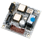
| Type / Part Number | AU7684N1x00 | AU7684N2x00 |
|---|---|---|
 |
|
|
| Feature | Compact, Low cost, High accuracy |
GNSS/INS/VS |
| Operation Mode Compare |
Leveling Calculation | Leveling Calculation GNSS/INS/VS (User-configurable) |
| Size | 35×35mm | 35×35mm |
| Mass | 30g Max | 30g Max |
| Power Supply Voltage |
8~28V |
8~28V |
| Communication Interface | RS232/CAN | RS232/CAN |
| Output Data | ・Acceleration (X,Y,Z) ・Angular velocity (X,Y,Z) ・Attitude angle (Roll,Pitch,Yaw) ・GPS : Latitude, Longitude, GPS velocity (GPS module connection is required) |
・Acceleration (X,Y,Z) ・Angular velocity (X,Y,Z) ・Attitude angle (Roll,Pitch,Yaw) ・GPS : Latitude, Longitude, GPS velocity (GPS module connection is required) |
| Angular Velocity | ±200°/s | ±200°/s |
| Acceleration | ±3G / ±6G | ±3G / ±6G |
| Angular Velocity Bias | 0.2 °/s rms | 0.2 °/s rms |
| Acceleration Bias | 5mG | 5mG |
| Operating Temp. Range | -40~85℃ | -40~85℃ |
| Bandwidth | 20Hz | 20Hz |
| Output Cycle | RS232C:200Hz Max CAN:1,000Hz Max |
RS232C:50Hz Max CAN:50Hz Max |
| Case Type Series | Waterproof Case: TAG300N1x00 Series Non-waterproof Case: TAG289N1x00 Series |
Waterproof Case: TAG300N2x00 Series Non-waterproof Case: TAG289N2x00 Series |
| Accessory | (Sold separately)Communication cable: Model No.EU8937N1000 Model No.EU8937N1001(GPS Module Connector Type) * Details of GPS Module |
(Sold separately)Communication cable: Model No.EU8937N1000 Model No.EU8937N1001(GPS Module Connector Type) * Details of GPS Module |
| Type / Part Number | TAG289N1x00 | TAG289N2x00 |
|---|---|---|
 |
|
|
| Feature | Compact, Low cost, High accuracy, Non-Waterproof |
GNSS/INS/VS Non-waterproof |
| Operation Mode Compare |
Leveling Calculation | Leveling Calculation GNSS/INS/VS (User-configurable) |
| Size | 45×64×33mm | 45×64×33mm |
| Mass | 250g Max | 250g Max |
| Power Supply Voltage | 8~28V | 58~28V |
| Communication Interface | RS232/CAN | RS232/CAN |
| Output Data | ・Acceleration (X,Y,Z) ・Angular velocity (X,Y,Z) ・Attitude angle (Roll,Pitch,Yaw) ・GPS : Latitude, Longitude, GPS velocity (GPS module connection is required) |
・Acceleration (X,Y,Z) ・Angular velocity (X,Y,Z) ・Attitude angle (Roll,Pitch,Yaw) ・GPS : Latitude, Longitude, GPS velocity (GPS module connection is required) |
| Angular Velocity | ±200°/s | ±200°/s |
| Acceleration | ±3G / ±6G | ±3G / ±6G |
| Angular Velocity Bias | 0.2 °/s rms | 0.2 °/s rms |
| Acceleration Bias | 5mG | 5mG |
| Operating Temp. Range | -40~85℃ | -40~85℃ |
| Bandwidth | 20Hz | 20Hz |
| Output Cycle | RS232C:200Hz Max CAN:1,000Hz Max |
RS232C:50Hz Max CAN:50Hz Max |
| Accessory | Communication/ Power supply Interface Cable * Details of GPS Module |
Communication/ Power supply Interface Cable * Details of GPS Module |